A major Winter Storm is just hours away from impacting the Northeast. An area of low pressure will be tracking across the Great Lakes region on Sunday and will take a track towards Pittsburgh. This will allow areas south of the PA/NY border to start off as rain showers. As the low pressure makes it track towards Pittsburgh, it will transfer its energy toward northern Virginia before pulling off the coast of the DELMARVA thanks to a high pressure system sitting to our north. This will lead to any liquid precipitation transition to freezing rain, sleet, and eventually snow. The same areas that have been hit hard over the last couple weeks, specifically Southern New England will likely get hit hard again with major snows.
Timing: Sunday - Tuesday. Yes this is a long duration event. The precipitation will not be all that heavy, however having 24-48 hours of constant precipitation, that will add up pretty fast especially over Central New York and Massachusetts.
Models have trended colder with this system since last night. So we have decided to increase snow totals slightly in PA, but Northern New Jersey and coastal areas in Southern New England were increased pretty significantly.
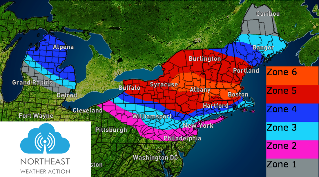
Zone by Zone break down:
Zone 1 (Grey): All snow, on the light side. A coating to 2" is likely.
Zone 2 (Pink): Rain to start, eventually transitioning to sleet and freezing rain Sunday Night into Monday. Up to .10" of ice accumulation is possible. Along with a coating-2" of snowfall.
Zone 3 (Light Blue): Rain to start, transitioning to a wintry mix by Sunday Evening. With the recent trend of a colder system, we have decided to up the ice accumulation forecast. Up to a quarter inch of ice accumulation is now possible. Power outages and down tree limbs cannot be ruled out, especially in Eastern Pennsylvania around Allentown to the Northwest Suburbs of New York City. Precipitation will transition to snow Sunday Night into Monday Morning. 2-4" of snowfall is possible.
Zone 4 (Dark Blue): Brief rain to start, quickly transitioning to sleet, then snow. 4-8" of snowfall is likely.
Zone 5 (Red): Mainly snow, 8-14" of new snowfall beginning on Sunday lasting through Monday.
Zone 6 (Orange): Mainly snow, 14-20" of new snowfall beginning on Sunday lasting through Monday.
Timing: Sunday - Tuesday. Yes this is a long duration event. The precipitation will not be all that heavy, however having 24-48 hours of constant precipitation, that will add up pretty fast especially over Central New York and Massachusetts.
Models have trended colder with this system since last night. So we have decided to increase snow totals slightly in PA, but Northern New Jersey and coastal areas in Southern New England were increased pretty significantly.
Zone by Zone break down:
Zone 1 (Grey): All snow, on the light side. A coating to 2" is likely.
Zone 2 (Pink): Rain to start, eventually transitioning to sleet and freezing rain Sunday Night into Monday. Up to .10" of ice accumulation is possible. Along with a coating-2" of snowfall.
Zone 3 (Light Blue): Rain to start, transitioning to a wintry mix by Sunday Evening. With the recent trend of a colder system, we have decided to up the ice accumulation forecast. Up to a quarter inch of ice accumulation is now possible. Power outages and down tree limbs cannot be ruled out, especially in Eastern Pennsylvania around Allentown to the Northwest Suburbs of New York City. Precipitation will transition to snow Sunday Night into Monday Morning. 2-4" of snowfall is possible.
Zone 4 (Dark Blue): Brief rain to start, quickly transitioning to sleet, then snow. 4-8" of snowfall is likely.
Zone 5 (Red): Mainly snow, 8-14" of new snowfall beginning on Sunday lasting through Monday.
Zone 6 (Orange): Mainly snow, 14-20" of new snowfall beginning on Sunday lasting through Monday.
Unless there are major shifts in the next 12 hours, this will likely be our final call as well. But as of now we will leave it as our second call in case we have to make any last second changes. Please be careful out there, and Southern New England, specifically around Boston, good luck with your snowfall removal. Not sure where you guys will be able to put all that snow! In the meantime enjoy your Saturday Night. ~Chris
 RSS Feed
