Over the last several days I have been mentioning the threat for a strengthening Nor'easter to impact the area Sunday into Monday, now that looks like a certainty. A clipper system out of Canada will phase with a low pressure system off the coast and rapidly develop this low into a Nor'easter. Since my last update yesterday evening, models have trended to phase these two system quicker, meaning more of a westerly track. In terms of precipitation this means a more rainy solution for Maine, and a bit more snowfall for upstate New York. The biggest change from my last map is definitely Maine. It was a very close call on which track this low would take and unfortunately for snow lovers it does not look to take the track you want it to.
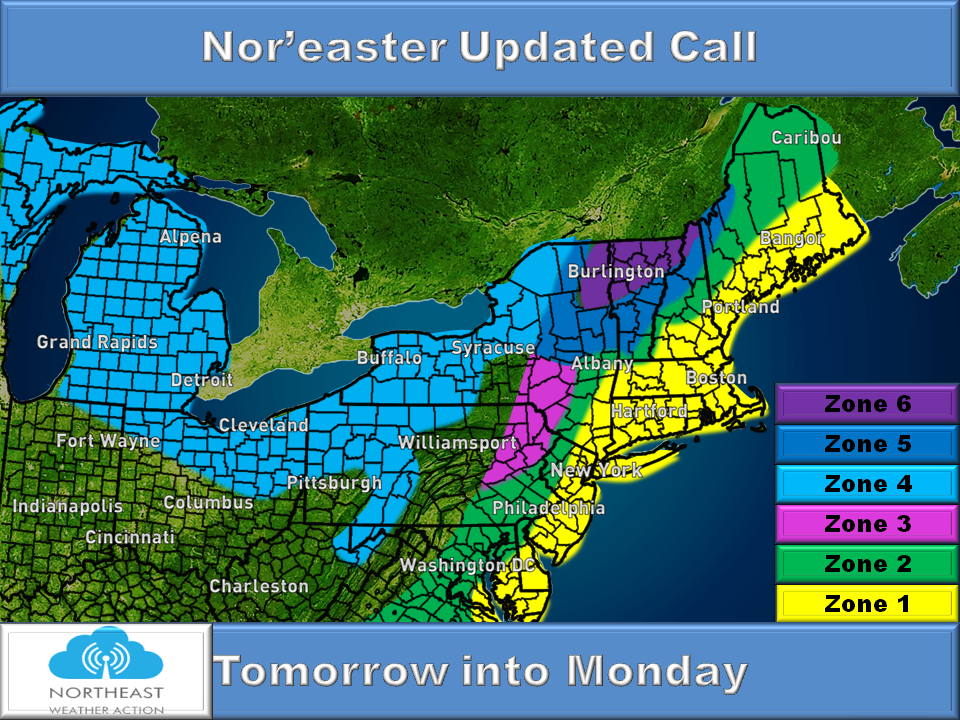
Timing: Tomorrow into Monday
Zone by Zone breakdown:
Zone 1 (Yellow): 1-3" of rainfall, with gusty winds especially as you NYC and northward. Coastal flooding is definitely a possibility, but nothing major.
Zone 2 (Green): Light to moderate rainfall. Up to 1" of rainfall expecting. More closer to the 1" mark as you head closer to the coast in this zone.
Zone 3 (Pink): Light mix of sleet and freezing rain changing to moderate rain. Up to 1" of rainfall before changing back to a brief period of sleet, freezing rain and snow towards the tail end of the storm. A coating to 1" of sleet/snow accumulation is possible. Up to a tenth of an inch of ice accretion is also possible, watch for slick spots especially at the onset of the storm.
Zone 4 (Light Blue): A coating to 2" of snowfall can expected. This moisture is mainly associated with the clipper system coming out of Canada. As you head north of Syracuse, NY that is where you get a bit of enhancement from the developing Nor'easter off the coast, but this area is too far East for any major impacts.
Zone 5 (Dark Blue): A period of rain switching to sleet and eventually to all snow as the system wraps up and intensifies. This area can expect 2-4" of new sleet and snowfall accumulation before all set and done.
Zone 6 (Purple): This is your bulls-eye area. Burlington, VT is smack-dab right in the middle of it. Anywhere in the purple may start off as a little rain before quickly changing to a moderate to heavy wet snowfall. 4-8" of snowfall is expected for you guys.
**Just a reminder this map DOES NOT include any lake effect snow that may be expected.**
That is all for now, hopefully when the next storm comes around we will be talking about a little more snowfall than rain, after all it is Winter! Our next shot at some snow will be from clipper system that will arrive here late Tuesday into Wednesday. Clippers do not bring with it much precipitation, so at this point I am just expecting light amounts. We will have more on that after this storm passes. If I need to issue a new forecast tomorrow, I will at some point during the late morning hours. Thank you all for the continuous support of Northeast Weather Action, we appreciate it greatly! Have an awesome Saturday Night. ~Chris
 RSS Feed
